100-year flood:
|
A flood that has a 1% chance of occurring in any given year
|
500-year flood:
|
A flood that has a .02% chance of occurring in any given year
|
Adaptation:
|
Action that helps cope with the effects of climate change - for example, construction of barriers, coastal mangrove restoration, and other living shorelines to protect against rising sea levels
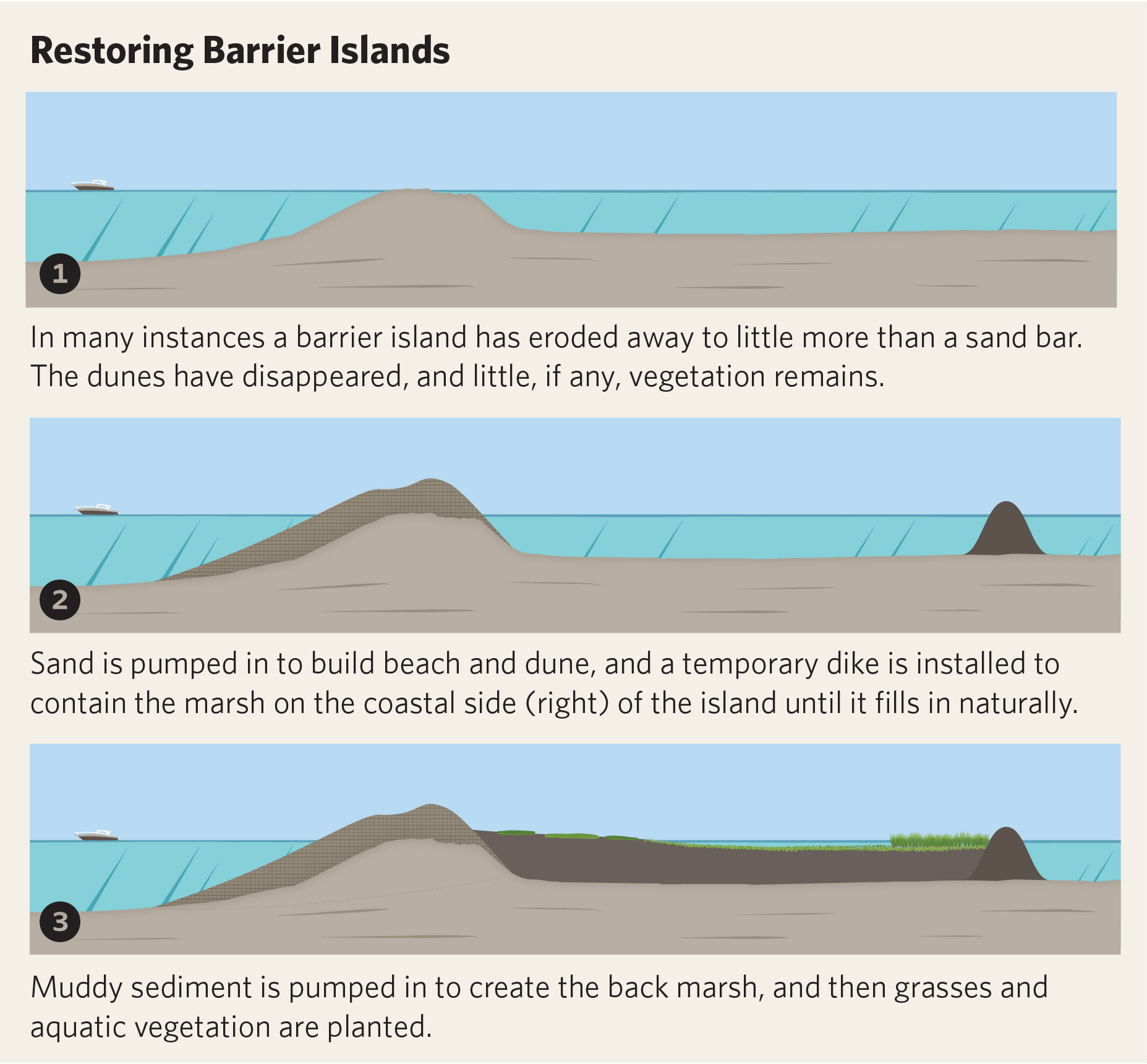
Illustration of barrier island restoration. Source: Audubon Magazine, Katie Peek, 2017
|
Adaptive Capacity:
|
The ability of a person, asset, or system to adjust to a hazard, take advantage of new opportunities, or cope with change
|
Advanced Circulation (ADCRIRC) Model:
|
Storm surge model that combines rain, atmospheric pressure, and wind forecasts to predict when, where, and to what extent flooding will inundate a coastal community with greater precision than other available models
|
Anthropogenic:
|
Resulting from or influenced by human activities
|
Astronomical tide:
|
The tidal level resulting from gravitational effects and not atmospheric influences
|
Base Flood Elevation (BFE):
|
Elevation of flooding, including wave height, having a 1% chance of being equaled or exceeded in any given year (also known as “base flood” and “100-year flood”). The BFE is the basis of insurance and floodplain management requirements and is shown on Flood Insurance Rate Maps (FIRMs)
|
Breakwater:
|
A structure protecting a shore area, harbor, anchorage, or basin from waves
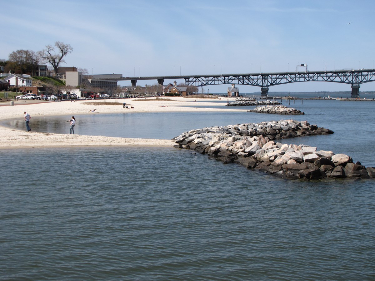 A series of breakwaters promoting sediment accretion at Colonial National Historic Park, Virginia. Source: NPS Photo by Steve Simon, 2012 A series of breakwaters promoting sediment accretion at Colonial National Historic Park, Virginia. Source: NPS Photo by Steve Simon, 2012
|
Brownfield:
|
A property whose expansion, redevelopment, or reuse may be complicated by the presence or potential presence of a hazardous substance, pollutant, or contaminant
|
Climate Change:
|
The long-term change in the average weather patterns that have come to define Earth’s local, regional and global climates
|
Climate Risk:
|
Refers to risk assessments based on formal analysis of the consequences, likelihoods and responses to the impacts of climate change and how societal constraints shape adaptation options
|
Coastal Flooding:
|
Flooding in areas that lie on the coast of a sea, ocean, or other large body of open water; typically, the result of extreme tidal conditions caused by severe weather
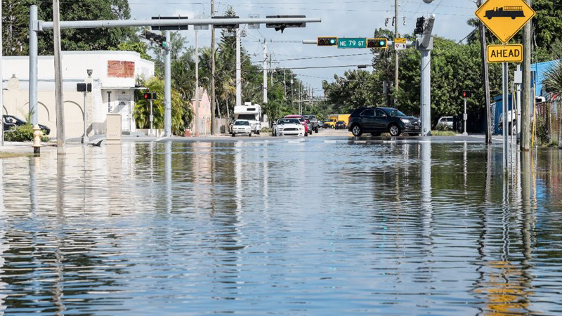 Flooding in Miami-Dade County in November 2020. Source: Miami-Dade County, 2020 Flooding in Miami-Dade County in November 2020. Source: Miami-Dade County, 2020
|
Compound Flooding:
|
Extreme events occurring in coastal areas where the interaction of high sea level and significant precipitation causes extreme flooding
|
Digital Elevation Model (DEM):
|
A specialized digital mapping database that represents the relief of a surface between points of known elevation
|
Elevation:
|
Distance above sea level
|
Flood Exposure:
|
The population and value of assets subject to flooding
|
Flood Risk:
|
The product of the vulnerability to flooding multiplied by the total value of the assets at risk of flooding
|
Flood Zones:
|
Geographic areas that the Federal Emergency Management Agency (FEMA) has defined according to varying levels of flood risk. These zones are depicted on a community's Flood Insurance Rate Map (FIRM). Each zone reflects the potential flood risk for the area
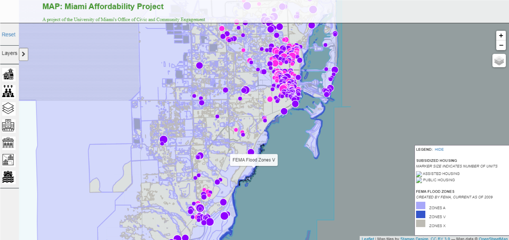 Source: University of Miami, Office of Civic and Community Engagement, 2020 Source: University of Miami, Office of Civic and Community Engagement, 2020
|
Flood Zone - High Risk:
|
High-risk flood areas are denoted with the letters A or V on FEMA flood maps and face the highest risk of flooding. Properties in a high-risk zone with a federally backed mortgage are required to purchase flood insurance as a condition of that loan. Also referred to as Special Flood Hazard Area (SFHA)
|
Flood Zones - Moderate to Low-Risk:
|
Moderate- to low-risk flood areas are designated with the letters B, C, and X on FEMA flood maps. In these areas, the risk of being flooded is reduced but not completely removed
|
Floodplain:
|
Any land area susceptible to being inundated by floodwaters from any source
|
Floodproofing - Dry:
|
A dry floodproofed structure is made watertight below the level that needs flood protection to prevent flood waters from entering
|
Floodproofing - Wet:
|
Wet floodproofing a structure consists of modifying the uninhabited portions (such as a crawlspace or a garage) to allow floodwaters to enter and exit
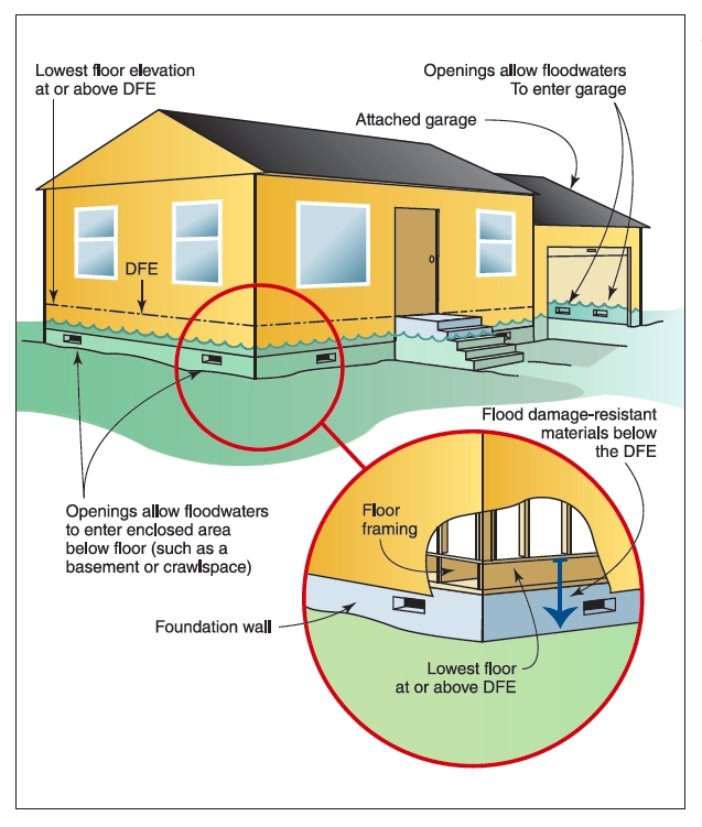 Wet floodproofing strategies, including openings that allow floodwaters to enter the basement. Source: Resilient Design Institute, 2015 Wet floodproofing strategies, including openings that allow floodwaters to enter the basement. Source: Resilient Design Institute, 2015
|
Fluvial (River Flood/River Discharge):
|
Excessive rainfall over an extended period of time that causes a river to exceed its capacity
|
Greenfield:
|
A greenfield development is a real estate construction project on previously undeveloped land such as agricultural land or unused land parcels
|
Green Infrastructure:
|
A system of urban and environmental strategies including stormwater management, climate adaptation, better air quality, sustainable energy production, clean water, healthy soils, and an improvement in the quality of life and experience of cities; also referred to as Blue-Green infrastructure
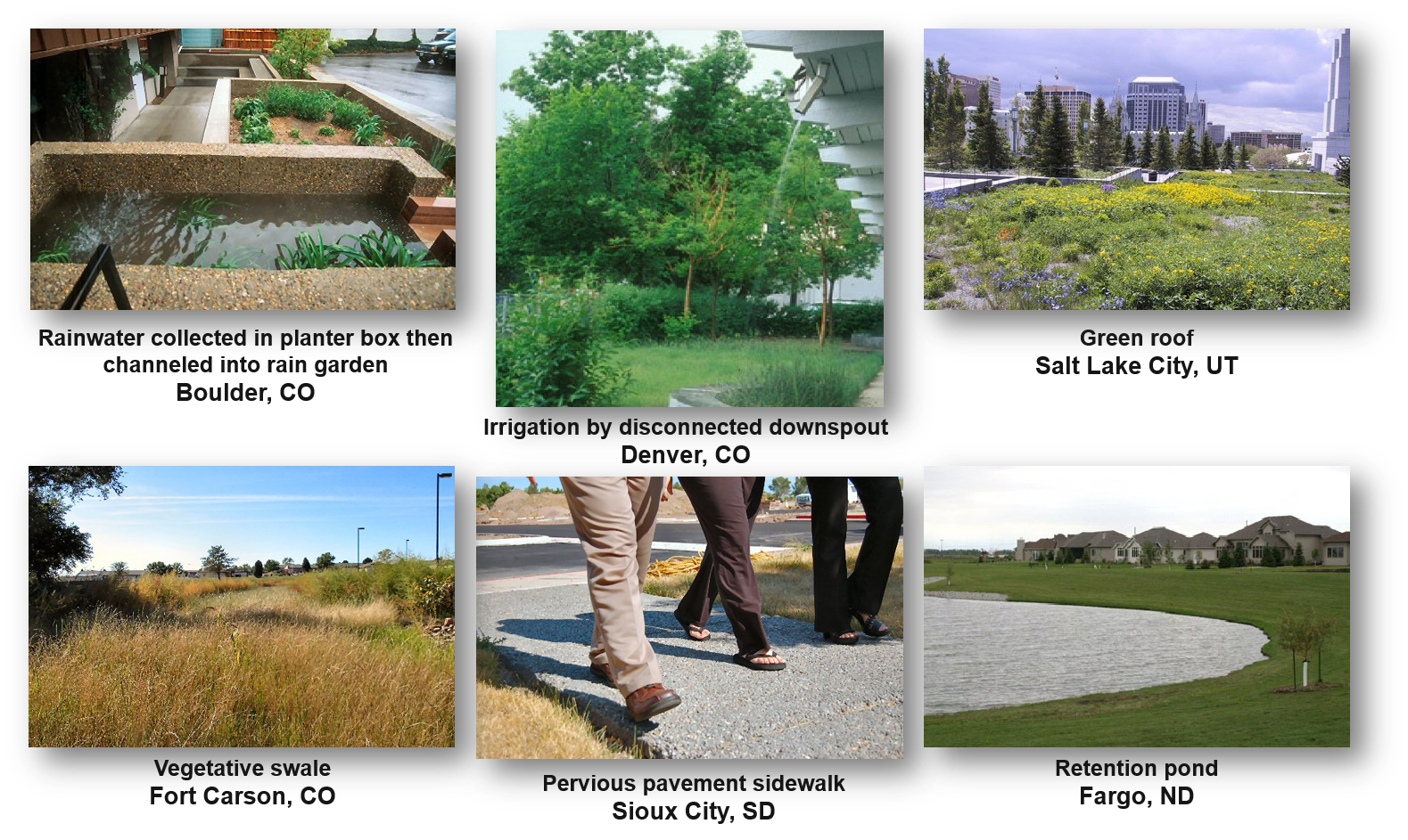 Source: EPA, 2020 Source: EPA, 2020
|
Groundwater Level:
|
Water that has permeated into the surface of the earth that forms into underground lakes called aquifers
|
Impervious Surface:
|
An artificial (pavement, road, industrial area, etc.) or natural surface (compacted clay in a desert environment) through which water, air, or roots cannot penetrate
|
Light Detection and Ranging (LiDAR) Technology:
|
A remote sensing method that uses light to measure ranges (variable distances) to generate precise, three-dimensional information about the shape of the Earth and its surface characteristics
|
Living Shorelines:
|
The use of plants or other natural elements — sometimes in combination with harder shoreline structures — to stabilize estuarine coasts, bays, and tributaries
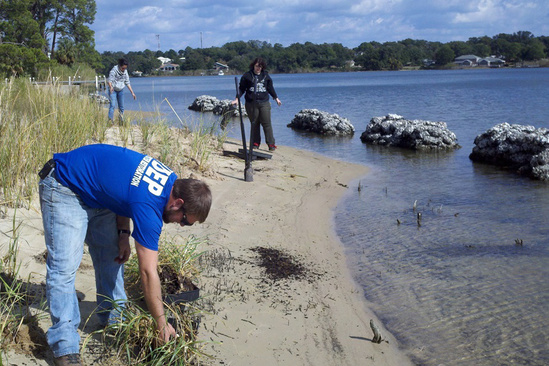 Florida DEP plants grasses along a Pensacola Bay shore protected with new reefs for oysters and other shellfish to grow. Source: NOAA, 2019 Florida DEP plants grasses along a Pensacola Bay shore protected with new reefs for oysters and other shellfish to grow. Source: NOAA, 2019
|
Mitigation:
|
Action that can reduce human-induced climate change, such as strategies to reduce greenhouse gas emissions or absorb greenhouse gases in the atmosphere
|
Pluvial (Surface Flood/Rainfall Runoff):
|
The occurrence where heavy rainfall creates a flood event independent of an overflowing water body
|
Projection (Climate):
|
Predictions of various future scenarios for climate change based on relationships between human choices, emissions, concentrations, and temperature change
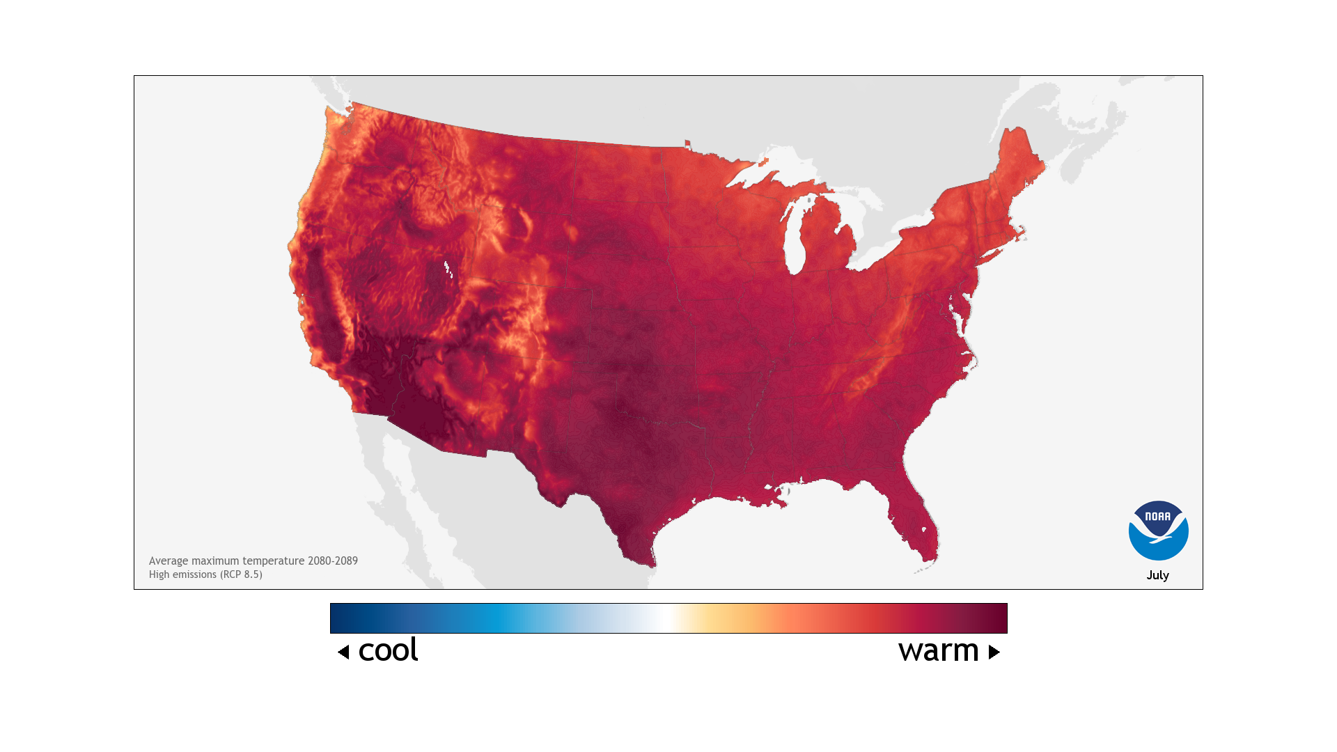
Colors show projected average daily high temperature for July 2080-2089, based on a high-emissions future. Source: NOAA, 2021
|
Resilience:
|
The capacity of social, economic, and environmental systems to cope with a hazardous event, trend or disturbance; responding or reorganizing in ways that maintain their essential function, identity, and structure, while also maintaining the capacity for adaptation, learning, and transformation
|
Risk:
|
A function of the likelihood/probability of a shock or stress combined with the consequence of the shock or stress
|
Sea Level Rise:
|
An increase in the level of the world’s oceans caused primarily by two factors related to global warming: melting ice sheets and glaciers, and thermal expansion of seawater as it warms
|
Sea, Lake, and Overland Surges from Hurricanes (SLOSH) Model:
|
A simulation model that computes storm surge heights from tropical cyclones using pressure, size, forward speed, and track data to create a model of the wind field that pushes the water around
|
Seawall/Bulkhead:
|
An embankment or wall for protection against waves or tidal action along a shore or waterfront; this can be constructed from human-made materials or natural solutions (e.g. plantings, living shorelines)
|
Shock:
|
An acute natural or human-made event or phenomenon threatening major loss of life, damage to assets, and a city’s ability to function and provide basic services, particularly for vulnerable populations
|
Storm surge:
|
The abnormal rise of water generated by a storm, over and above the predicted astronomical tides
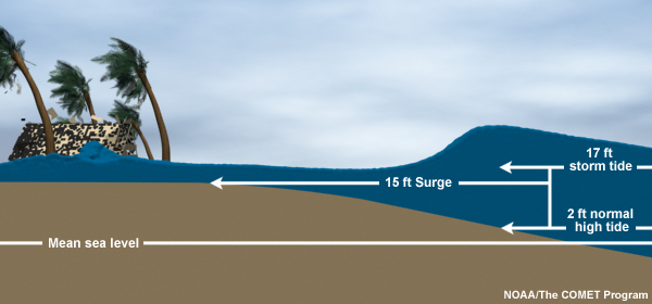
An explanation of storm surge vs. storm tide. Source: NOAA, 2020
|
Storm tide
|
Water level rise due to the combination of storm surge and the astronomical tide
|
Stressor:
|
A chronic (ongoing or cyclical) natural or human-made event or phenomenon that renders the city less able to function and provide basic services, particularly for vulnerable populations
|
Sunny day flooding/ tidal flooding:
|
Flooding caused by exceptionally high tides, often called king tides
|
Typology:
|
The identification of essential types of buildings or elements
|
Urban heat/ Heat Island:
|
Urban development that replaces open land and vegetation, absorbing more heat and raising temperatures within urban spaces
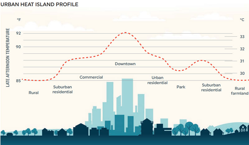 A display of the urban heat island. Source: Urban Land Institute, 2020 A display of the urban heat island. Source: Urban Land Institute, 2020
|
Vertical Datums:
|
A surface of zero elevation to which heights of various points are referenced for use in digital mapping, among other uses; the current vertical datum for the contiguous United States and Alaska is the North American Vertical Datum of 1988 (NAVD 88)
|
Vulnerability:
|
The inability of systems (environmental, social, economic) to cope with and recover from the multifaceted stressors brought about by climate change
|

